
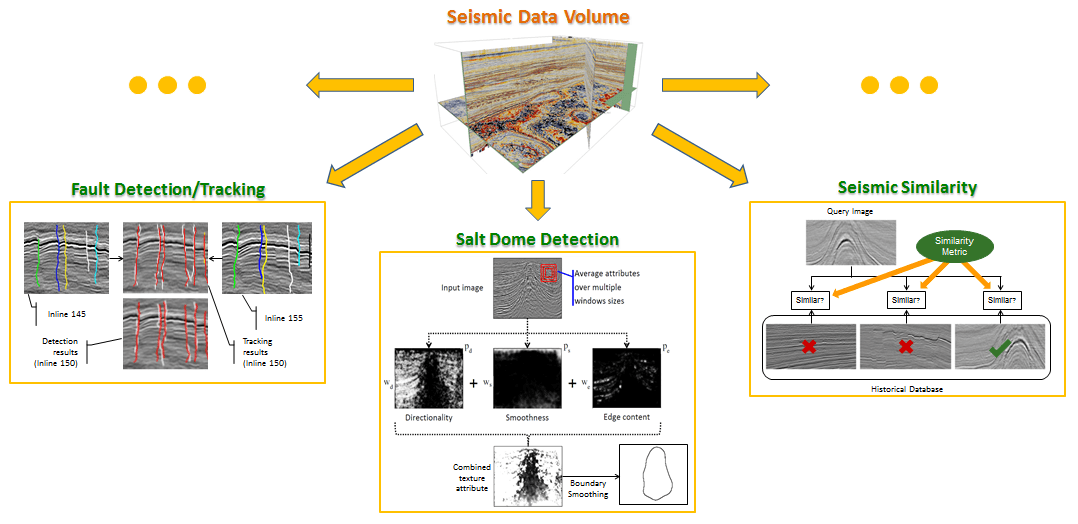
In this project, we study various seismic data interpretation problems that are important for oil exploration. Typically we work with migrated seismic datasets. The objective is to develop computer algorithms that are capable of identifying and labeling geological structures that are indicative of possible existence of an oil field nearby. Currently, our effort is dedicated to the following tasks. In fault detection, we study the characterization and detection of faults. Similarly, in salt dome detection, we study how to characterize and label salt domes. To achieve high efficiency for salt dome labeling, we explore how to track an initially labeled salt dome boundary across a 3D volume. In addition to these traditional applications, we also look into new areas such as seismic image similarity, which is a metric used to evaluate similarity between seismic datasets. Other research activities in this project include, but are not limited to, application of machine learning to seismic signal processing, development of new geological attributes for interpretation, etc. In the future, we plan to build an interactive environment for all the tasks. Our future plan will also include exploration using raw data instead of migrated data.
Research Outcomes:
Some of the research outcomes of the project are:
- SalSi: A New Seismic Attribute for Salt Dome Detection
- Extending the Seismic Coherence Attribute to New Dimensions
- Phase Congruency in Computational Seismic Interpretation
- A Texture-based Interpretation of Salt Domes
- Learning from a Dictionary: The Case of Detecting Salt Domes
- DTSIM: A Directional Texture Similarity Metric
- Characterization of Migrated Seismic Volumes Using Texture Attributes: A Comparative Study
- Weakly-supervised Labeling of Seismic Volumes Using Reference Exemplars
- Tensor-based Subspace Learning for Tracking Salt-dome Boundaries Constrained by Seismic Attributes
SalSi: A New Seismic Attribute for Salt Dome Detection
Saliency detection aims to highlight the salient regions in images and videos by taking into consideration the biological structure of the human vision system (HVS). As a great deal of research in computational cognitive science suggests, HVS has evolved to reduce the amount of the sensory data information gathering stage, also known as the task-free visual search, by focusing on the perceptually salient segments of visual data that convey the most useful information about the scene.
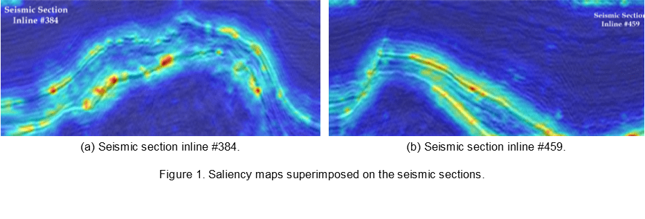
We proposed a saliency-based attribute, SalSi, to detect salt dome bodies within seismic volumes. Using SalSi, we highlight the parts of the seismic volume that receive highest attention from the human interpreter, and based on the salient features of a seismic image, we detect the salt domes. The saliency maps of two seismic section inlines are shown in Figure 1, which demonstrates that the proposed method highlights the salt dome boundaries.
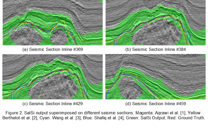
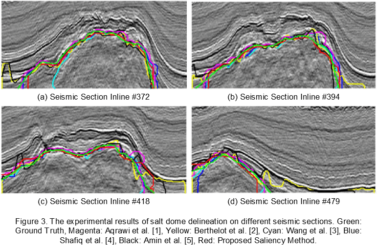
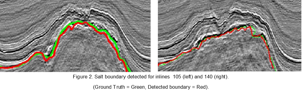
Experimental results show the effectiveness of SalSi on the real seismic dataset acquired from the North Sea, F3 block. Subjectively, we have used the ground truth and the output of different salt dome delineation algorithms to validate the results of SalSi. The output of different delineation algorithms and regions highlighted by SalSi in green are shown in Figure 2. SalSi, originally designed to detect salt domes, can be modified to capture chaotic horizons and faults as well from seismic volumes. SalSi can be used to initialize algorithms, tracking salt domes in seismic volume, salt dome delineation and to reduce computational complexity of algorithms. The results of salt domes delineation using SalSi are shown in Figure 3.
For the objective evaluation of results, we have used the receiver operating characteristics (ROC) curves and area under the curves (AUC) to demonstrate that SalSi is a promising and an effective attribute for seismic interpretation. The experimental results show that the proposed framework is very fast and achieves salt dome delineation comparable to the state of the art methods. The initial results show a promising future of the proposed framework for salt dome delineation and very good potential in seismic interpretation.
References:
1. A. A. Aqrawi, T. H. Boe, and S. Barros, “Detecting salt domes using a dip guided 3D Sobel seismic attribute,” in Expanded Abstracts of the SEG 81st Annual Meeting, 2011
2. A. Berthelot, A. HS Solberg, and L. J. Gelius, “Texture attributes for detection of salt,” Journal of Applied Geophysics, vol. 88, pp. 52–69, 2013.
3. Z. Wang, T. Hegazy, Z. Long, and G. AlRegib, “Noise-robust detection and tracking of salt domes in post-migrated volumes using texture, tensors, and subspace learning,” Geophysics, November 2015, v. 80, p. WD101-WD116 .
4. M. Shafiq, Z. Wang, A. Amin, T. Hegazy, M. Deriche, and G. AlRegib, “Detection of salt-dome boundary surfaces in migrated seismic volumes using gradient of textures,” Expanded Abstracts of the SEG 85th Annual Meeting, pp. 1811-1815, New Orleans, Louisiana, Oct. 18-23, 2015.
5. M. Shafiq, T. Alshawi, Z. Long, and G. AlRegib, “SalSi: A new seismic attribute for salt dome detection,” to be presented at IEEE Intl. Conf. on Acoustics, Speech and Signal Processing (ICASSP), Shanghai, China, Mar. 20-25, 2016.
6. A. Amin and M. Deriche, “Salt dome detection using a codebook based learning model”, in preparation.
Extending the Seismic Coherence Attribute to New Dimensions
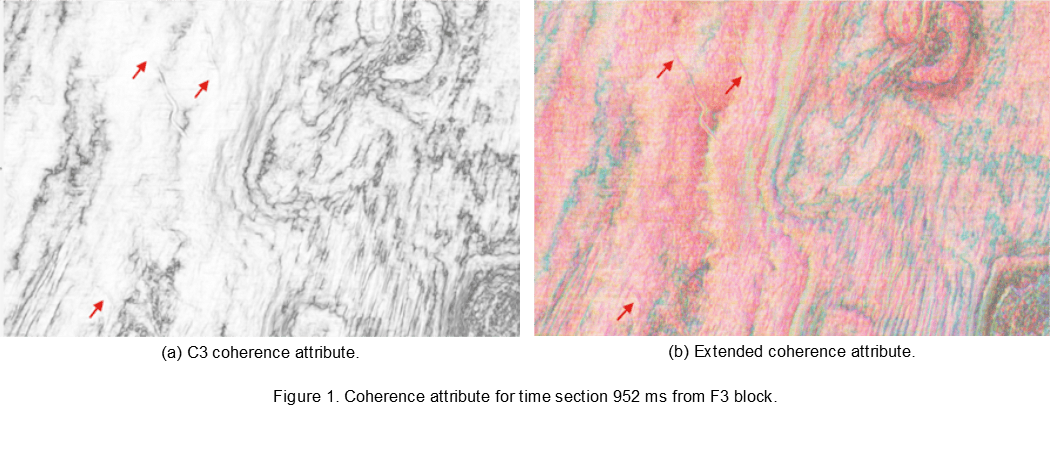
The coherence attribute has proven to be a very useful attribute for highlighting structural and stratigraphic discontinuities such as faults, fractures and channels in 3-D seismic volumes. While it has been widely used in academia and industry, few advances have been made to how the coherence attribute is computed since its inception two decade ago. The coherence attribute is commonly calculated by extracting an eigenstructure-based attribute from the covariance matrix of seismic traces within a small analysis window. This can be viewed as unfolding a small analysis tensor along the time direction. In a recent paper [1] we will present at the EAGE 2016 conference, we show that unfolding the tensor along all three directions (time, crossline, and inline) gives a much richer coherence attribute that can help interpreters highlight more intricate geological structures. We also proposed a preprocessing stage based on a normalized multivariate Gaussian kernel that can help weigh traces by their relative proximity to the analysis trace. We show that this greatly enhances the results, and gives the seismic interpreters more flexibility at the same time. The figures above show the original coherence attribute and the proposed generalized coherence attribute. The generalized attribute offers a higher level of detail as well as colored features. The reader can notice that the channels highlighted in the figures appear much more clearly in the generalized attribute.
References:
1. Y. Alaudah and G. AlRegib, “A Generalized tensor-based coherence attribute,” at the 78th EAGE Annual Conference & Exhibition, Vienna, Austria, May 30-June 2, 2016.
2. Y. Alaudah, M. Shafiq, and G. AlRegib, “A hybrid spatio-frequency approach for delineating subsurface structures in seismic volumes,” SIAM conference on Imaging Science, New Mexico, USA, May 23-26, 2016.
Phase Congruency in Computational Seismic Interpretation
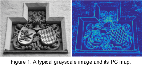
Phase Congruency (PC) highlights the discontinuities in images with varying illumination and contrast using the congruency of phase in Fourier components. PC does not only detect subtle variations in the image intensity but can also highlight the anomalous values to develop a deeper understanding of the image’s content and context. Figure 1 shows a typical grayscale image and its PC map.
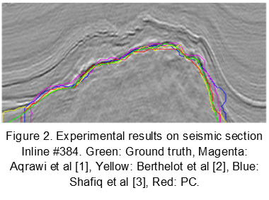
We proposed a new method based on PC for computational seismic interpretation with an application to subsurface structures delineation within migrated seismic volumes. The proposed method is suitable for segmenting seismic volumes having weak seismic reflections, varying illumination and contrast. This proposed workflow for salt dome delineation can be modified to capture other geological structures such as chaotic horizons and faults. We show the effectiveness of the proposed method as compared to the edge and texture-based methods for salt dome boundary detection. A sample result on a real dataset from the North Sea, F3 is shown in Figure 2. The experimental results show that the proposed method is not only computationally very efficient but also outperforms the state of the art methods for salt dome delineation. The proposed method is expected to reduce the time for seismic interpretation and become a handy tool in the interpreter’s toolbox for delineating geological structures within migrated seismic volumes.
References:
1. A. A. Aqrawi, T. H. Boe, and S. Barros, “Detecting salt domes using a dip guided 3D Sobel seismic attribute,” in Expanded Abstracts of the SEG 81st Annual Meeting, 2011.
2. A. Berthelot, A. HS Solberg, and L. J. Gelius, “Texture attributes for detection of salt,” Journal of Applied Geophysics, vol. 88, pp. 52–69, 2013.
3. M. Shafiq, Z. Wang, A. Amin, T. Hegazy, M. Deriche, and G. AlRegib, “Detection of salt-dome boundary surfaces in migrated seismic volumes using gradient of textures,” Expanded Abstracts of the SEG 85th Annual Meeting, pp. 1811-1815, New Orleans, Louisiana, Oct. 18-23, 2015.
4. M. Shafiq, Y. Alaudah, and G. AlRegib, “Phase Congruency for image understanding with applications in computational seismic interpretation,” submitted to IEEE Intl. Conference on Image Processing (ICIP), Phoenix, Arizona, USA, Sep. 25-28, 2016.
5. M. Shafiq, Y. Alaudah, and G. AlRegib, “A hybrid approach for salt dome delineation within migrated seismic volumes,” at the 78th EAGE Annual Conference & Exhibition, Vienna, Austria, May 30-June 2, 2016.
6. M. Shafiq and G. AlRegib, “A noise robust approach for delineating subsurface structures within migrated seismic volumes,” at the 78th EAGE Annual Conference & Exhibition, Vienna, Austria, May 30-June 2, 2016.
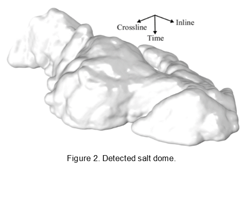
A Texture-based Interpretation of Salt Domes
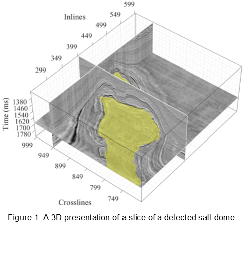
Salt domes are an important diapir-shaped geophysical structures in the Earth’s subsurface that are impermeable and contain hints about petroleum and gas reservoirs. Therefore, determining the accurate location of the salt domes within migrated seismic volumes is one of the key steps in the exploration projects.
We proposed a novel seismic attribute, three-dimensional gradient of textures (3D-GoT), for delineating geophysical structures such as salt domes within migrated seismic volumes. The 3D-GoT computes an attribute map by measuring the dissimilarity between the neighboring cubes around each voxel in seismic volume across crossline, inline and time directions. The experimental results on real seismic data from the North Sea demonstrate that the 3D-GoT delineates salt domes with high accuracy and precision and outperforms the state of the arts methods of salt dome delineation. A 3D view of seismic volume containing a salt dome with three different slices is shown in Figure 1. The detected salt dome volume is illustrated in Figure 2.
References:
1. M. Shafiq, Z. Wang, G. AlRegib, A. Amin, and M. Deriche, “A texture-based interpretation workflow with application to delineating salt domes,” submitted to Interpretation, March, 2016.
2. Z. Wang, T. Hegazy, Z. Long, and G. AlRegib, “Noise-robust detection and tracking of salt domes in post-migrated volumes using texture, tensors, and subspace learning,” Geophysics, 80(6), WD101-WD116.
3. M. Shafiq, Y. Alaudah, and G. AlRegib, “A hybrid approach for salt dome delineation within migrated seismic volumes,” at the 78th EAGE Annual Conference & Exhibition, Vienna, Austria, May 30-June 2, 2016.
4. M. Shafiq and G. AlRegib, “A noise robust approach for delineating subsurface structures within migrated seismic volumes,” at the 78th EAGE Annual Conference & Exhibition, Vienna, Austria, May 30-June 2, 2016.
5. M. Shafiq, T. Alshawi, Z. Long, and G. AlRegib, “The role of visual saliency in seismic interpretation with an application to salt dome delineation,” SIAM conference on Imaging Science, New Mexico, USA, May 23-26, 2016.
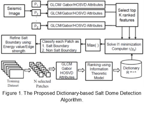
Learning from a Dictionary: The Case of Detecting Salt Domes
One of the most important tasks in seismic data interpretation is the detection of salt bodies as most of the important reservoirs are trapped around such bodies. Salt domes are largely subsurface geologic structures that consist of cylinder-like salt bodies. Major accumulations of oil and Gas are associated with salt domes. Unfortunately, salt dome detection is a difficult and a time consuming task especially in the case of 3D seismic volumes.
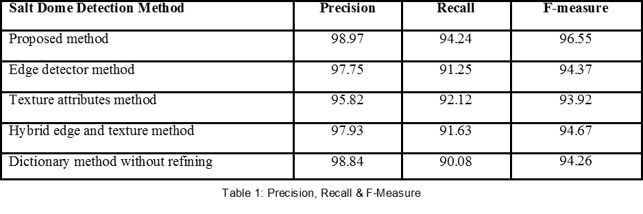
In this work, we developed a patch-based approach for salt dome detection using a dictionary-based classifier. The algorithm overcomes the drawbacks of existing texture-based salt dome detection techniques; which are heavily dependent upon the relevance of attributes to the geological nature of salt domes and the number of attributes used for classification. This dictionary-based method uses the attributes derived from the Gray Level Co-occurence Matrix (GLCM), the Gabor filter, and the Higher Order Singular Value Decomposition (HOSVD). An information theoretic-based framework is used to rank the attributes; the top ranked attributes are then selected for training and classification.
Contrary to other texture attributes-based salt dome detection techniques, our algorithm works with a minimum set of features and is shown to be independent of the amplitude variations in seismic data. We tested the proposed algorithm on the Netherlands offshore F3 block. Our experiments show excellent detection results of salt bodies with high accuracy superior to existing gradient-based and texture-based techniques. The overall structure of the proposed algorithm is shown in Figure 1.
References:
1. A. Amin, M. Deriche, Z. Wang, and G. AlRegib, “A Novel approach for salt dome detection using a dictionary-based classifier”, submitted to IEEE Transactions on Image Processing, March , 2016.
2. A. Amin and M. Deriche. ” New attributes for salt dome detection in 3D seismic data using higher order SVD.” submitted to IEEE Intl. Conference on Image Processing (ICIP), Phoenix, Arizona, USA, Sep. 25-28, 2016.
3. A. Amin, M. Deriche, T. Hegazy, Z. Wang, and Ghassan AlRegib, “A novel approach for salt dome detection using a dictionary-based classifier,” Expanded Abstracts of the SEG 85th Annual Meeting, pp. 1816-1820, New Orleans, Louisiana, Oct. 18-23, 2015.
4. A. Amin and M. Deriche. “A hybrid approach for salt dome detection in 2D and 3D seismic data.” Proc. IEEE ICIP 2015, Québec City, Canada, Sept. 27-30, 2015.
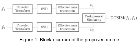
DTSIM: A Directional Texture Similarity Metric
Image characterization is an essential tool to aid the process of image analysis and retrieval especially with the exponential growth of visual and pictorial content. Texture is an important feature of a broad spectrum of images. Such a feature has been widely utilized in various applications such as image classification and segmentation. For example, texture attributes have been widely used in salt body segmentation in seismic volumes.
In a recent paper we submitted to the International Conference on Image Processing (ICIP 2016), we proposed a directional texture similarity metric (DTSIM) based on the singular value decomposition (SVD) of the curvelet coefficients in which the singular values are trimmed adaptively via effective rank approximation. DTSIM is designed for images that have repeating structures and directional content such as texture, fingerprint, and seismic images. The block diagram of the proposed metric is depicted in Figure 1.
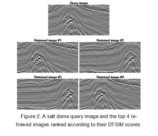
A retrieval experiment was set up to evaluate the performance of the metric. DTSIM outperforms state-of-the-art texture similarity metrics by 11% and 9% in terms of retrieval accuracy on CUReT and PerTex texture databases, respectively. In addition, DTSIM achieved 91% retrieval accuracy on the seismic image database LANDMASS-2 outperforming other seismic similarity metrics. Figure 2 shows a retrieval example using DTSIM showing its ability to retrieve images with similar structures.
References:
1. H. Al-Marzouqi and G. AlRegib, “Curvelet transform with learning-based tiling,” submitted to the Elsevier Signal Processing: Image Communication Journal, February 2016.
2. M. Alfarraj, Y. Alaudah, and G. AlRegib, “DTSIM: A directional texture similarity metric,” submitted to IEEE Intl. Conference on Image Processing (ICIP), Phoenix, Arizona, USA, Sep. 25-28, 2016.
3. Y. Alaudah and G. AlRegib, “A curvelet-based distance measure for seismic images,” Proc. IEEE ICIP 2015, Québec City, Canada, Sept. 27-30, 2015.
4. Z. Long, Y. Alaudah, M. Qureshi, M. Farraj, Z. Wang, A. Amin, M. Deriche, and G. AlRegib, “Characterization of migrated seismic volumes using texture attributes: a comparative study,” Expanded Abstracts of the SEG 85th Annual Meeting, pp. 1744-1748, New Orleans, Louisiana, Oct. 18-23, 2015.
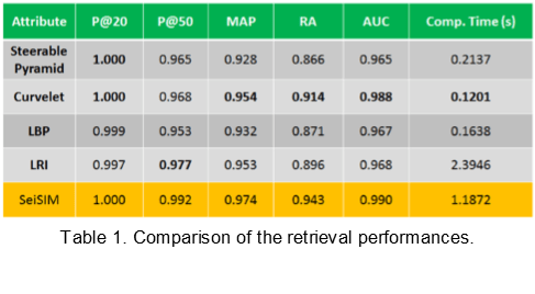
Characterization of Migrated Seismic Volumes Using Texture Attributes: A Comparative Study
In image processing, texture attributes are quantities generated from a texture pattern that capture the unique spatial distribution of the pixel intensities. Although texture attributes such as GLCM and Gabor features have been employed in some seismic interpretation applications with success, many more powerful texture analysis techniques developed in the image processing community have not yet been exposed adequately to exploration geophysicists. Therefore, in this work, we conduct a comparative study examining several typical texture attributes with respect to their capability of characterizing a seismic volume. We hope this study will help provide more alternative attributes for seismic exploration.
The attributes we examine here can be categorized into frequency or space domain techniques. For the frequency domain, we explore the steerable pyramid (SP) [1], and the curvelet transform (CT) [2]. These are two typical extensions of the standard wavelet transform (WT) [3], which is probably the most popular technique for spectral content-based image and texture analysis. For the space domain, we study the local binary pattern (LBP) [4] and the local radius index (LRI) [5]. LBP has been widely used for very successful texture analysis due to its robustness and computational efficiency, while LRI is one of the newer variants of the LBP.
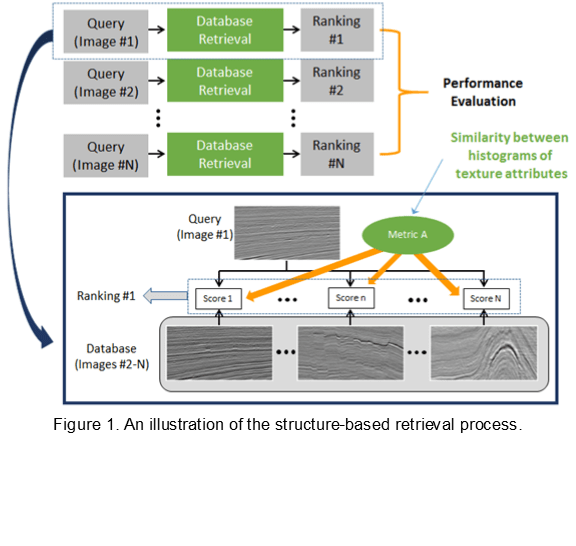
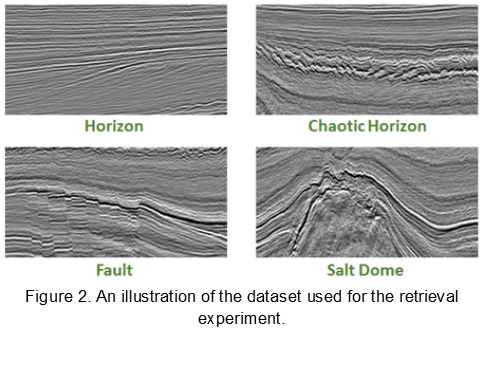
The attributes are examined in the context of image retrieval based on structural similarity, as illustrated in Figure 1. Figure 2 shows examples of the dataset we use. The retrieval results are given in Table 1, where SeiSIM [6] is used as a benchmark. According to the results, we conclude that all these attributes demonstrate great potential to effectively capture the characteristics of different geological structures, with CT and LRI being the most promising ones. In addition, CT is the most computationally efficient among all the techniques.
References:
1. Simoncelli, E., W. Freeman, E. Adelson, and D. Heeger, 1992, Shiftable multiscale transforms: Information Theory, IEEE Transactions on, 38, 587–607. Candès , E., L. Demanet, D. Donoho, and L. Ying, 2005, Fast discrete curvelet transforms: multiscale modelling and simulations, 5, 861–899. Chui, C. K., 2014, An introduction to wavelets: Academic press, 1.
2. Ojala, T., M. Pietikainen, and T. Maenpaa, 2002, Multiresolution gray-scale and rotation invariant texture classification with local binary patterns: IEEE Transactions on Pattern Analysis and Machine Intelligence, 24, 971–987.
3. Zhai, Y., D. L. Neuhoff, and T. N. Pappas, 2013, Local radius index-a new texture similarity feature: International Conference on Acoustics, Speech and Signal Processing (ICASSP), IEEE, 1434–1438.
4. Z. Long ., Z. Wang, and G. AlRegib, 2015, SeiSIM: structural similarity evaluation for seismic data retrieval: Presented at the 2015 IEEE ICCSPA, IEEE.
5. Z. Long, Y. Alaudah, M. Qureshi, M. Farraj, Z. Wang, A. Amin, M. Deriche, and G. AlRegib, “Characterization of migrated seismic volumes using texture attributes: a comparative study,” Expanded Abstracts of the SEG 85th Annual Meeting, pp. 1744-1748, New Orleans, Louisiana, Oct. 18-23, 2015.
6. H. Al-Marzouqi and G. AlRegib, “Curvelet transform with learning-based tiling,” submitted to the Elsevier Signal Processing: Image Communication Journal, February 2016.
7. M. Alfarraj, Y. Alaudah, and G. AlRegib, “DTSIM: A directional texture similarity metric,” submitted to IEEE Intl. Conference on Image Processing (ICIP), Phoenix, Arizona, USA, Sep. 25-28, 2016.
8. Y. Alaudah and G. AlRegib, “A curvelet-based distance measure for seismic images,” Proc. IEEE ICIP 2015, Québec City, Canada, Sept. 27-30, 2015.
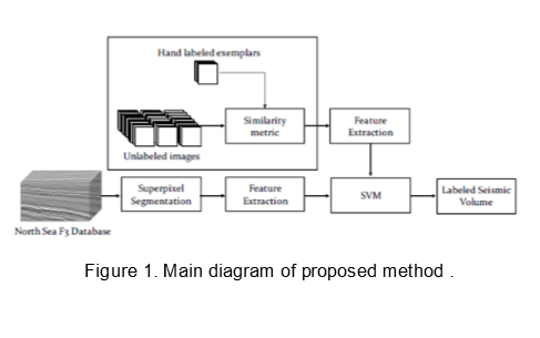
Weakly-supervised Labeling of Seismic Volumes Using Reference Exemplars
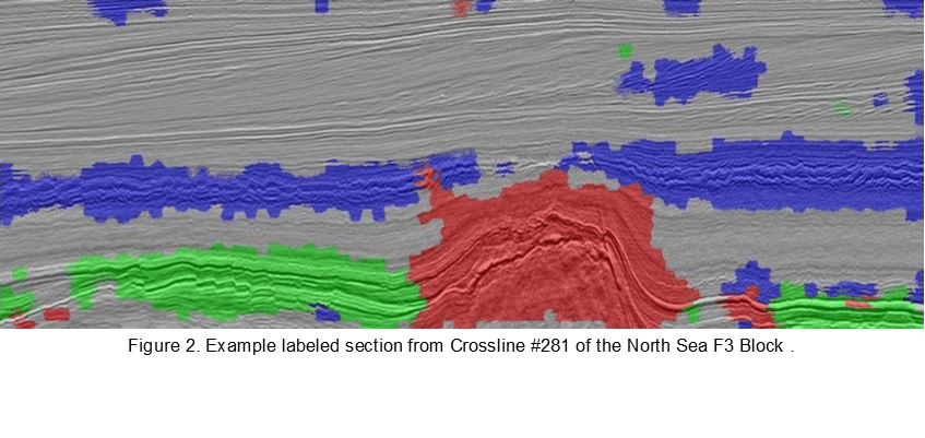
Localizing seismic structures that can form traps for hydrocarbon reservoirs within large seismic volumes is a very challenging task. Due to the lack of large amount of accurately labeled data, it becomes difficult to use powerful machine learning approaches (such as Convolutional Neural Networks) to achieve this task. In a recent paper submitted to the International Conference on Image Processing (ICIP 2016) we proposed using a directional similarity metric to extract data having similar geological structures to several hand-labeled ‘exemplars’. This process produces a large number of images that can be assigned the same classes as the hand-labeled exemplars. Features based on the singular values of curvelet coefficients are extracted and used to train a Support Vector Machine (SVM). This SVM is then used to label seismic sections segmented using superpixels. The overall diagram of the proposed method is shown in Figure 1. Experiments on reference seismic sections in the Netherlands North Sea seismic dataset result in 73.8% mean pixel accuracy and 75.5% mean class accuracy, with an average labeling time of 5.2 seconds per section. A sample labeled section from Crossline #281 of the North Sea F3 Block is shown in Figure 2.
References:
1. Y. Alaudah and G. AlRegib, “Weakly-supervised labeling of seismic volumes using reference exemplars,” submitted to IEEE Intl. Conference on Image Processing (ICIP), Phoenix, Arizona, USA, Sep. 25-28, 2016.
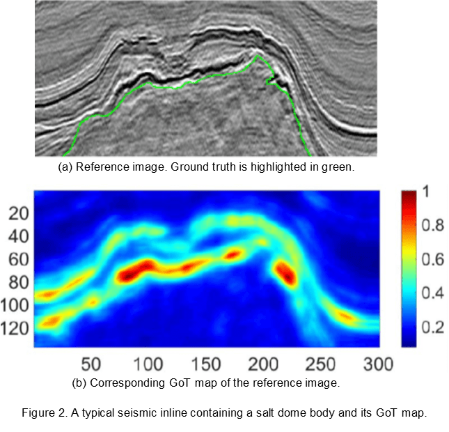
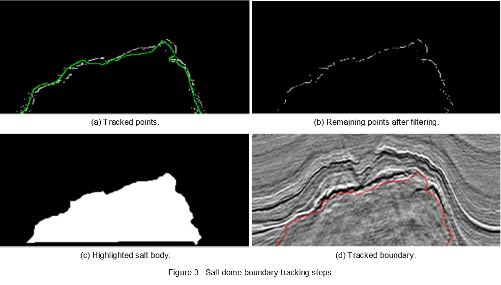
Tensor-based Subspace Learning for Tracking Salt-dome Boundaries Constrained by Seismic Attributes
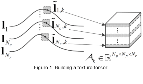
In the past year, we proposed a method to delineate salt dome structures by tracking manually labeled boundaries through seismic volumes. We first extract texture features from boundary regions using the tensor-based subspace learning method. Then, we utilize one seismic attribute, the gradient of texture (GoT), as a constraint on the tracking process. Using texture features and GoT maps, we can identify tracked points and optimally connect them to synthesize the boundaries. The proposed method is evaluated using real-world seismic data and experimental results show that it outperforms the state of the art in accuracy, robustness, and computational efficiency.
Figure 1 illustrates the process that builds texture tensors from the boundaries of reference sections. We define Nr neighboring seismic sections as reference sections, in which the corresponding boundaries, denoted lb, b=1,… ,Nr, are manually labeled. To fully capture texture information along all reference boundaries, we focus on texture patches centered at boundary points with a size of Np × Np. Therefore, third-order texture tensors with a size of Np × Np × Np can be built from these patches.
To increase the robustness of tracking, we select the GoT attribute as a constraint because of its capability of describing texture differences between the salt dome and its neighboring rock strata. Figure 2 illustrates the reference image and its corresponding GoT map. By building texture tensors from reference images and GoT maps, we can synthesize the tracked boundaries as Figure 3 shows.
References:
1. Z. Wang, Z. Long, and G. AlRegib, “Tensor-based subspace learning for tracking salt-dome boundaries constrained by seismic attributes,” to be presented at IEEE Intl. Conf. on Acoustics, Speech and Signal Processing (ICASSP), Shanghai, China, Mar. 20-25, 2016.
2. Z. Wang, Z. Long, and G. AlRegib, “Tensor-based subspace learning for tracking salt-dome boundaries,” Proc. IEEE ICIP 2015, Québec City, Canada, Sept. 27-30, 2015.
3. M. Shafiq, Z. Wang, and G. AlRegib, “Seismic interpretation of migrated data Using edge-based geodesic active contours,” Proc. IEEE Global Conf. on Signal and Information Processing (GlobalSIP), Orlando, Florida, Dec. 14-16, 2015.
The Team:
| Name | Title | Affiliation |
|---|---|---|
| Dr. Mohammed Deriche | Associate Professor | Electrical Engineering Department, KFUPM |
| Dr. Suhail Ibrahim A Al-Dharrab | Assistant Professor | Electrical Engineering Department, KFUPM |
| Dr. Naveed Iqbal | Post-Doctoral Associate | Electrical Engineering Department, KFUPM |
| Asjad Amin | Graduate Student | Electrical Engineering Department, KFUPM |
| Hilal Hudan Nuha | Graduate Student | Electrical Engineering Department, KFUPM |
| Muhammad Ali Qureshi | Graduate Student | Electrical Engineering Department, KFUPM |
| Dr. Ghassan AlRegib | Associate Professor | School of Electrical and Computer Engineering, Georgia Tech |
| Dr. Zhigang Peng | Associate Professor | School of Earth and Atmospheric Sciences, Georgia Tech |
| Dr. Zhiling Long | Post-Doctoral Fellow | School of Electrical and Computer Engineering, Georgia Tech |
| Yazeed Alaudah | Graduate Student | School of Electrical and Computer Engineering, Georgia Tech |
| Motaz Al Farraj | Graduate Student | School of Electrical and Computer Engineering, Georgia Tech |
Zefeng Li |
Graduate Student | School of Earth and Atmospheric Sciences, Georgia Tech |
| Muhammad Amir Shafiq | Graduate Student | School of Electrical and Computer Engineering, Georgia Tech |
| Zhen Wang | Graduate Student | School of Electrical and Computer Engineering, Georgia Tech |